Where is Qeshm Island?
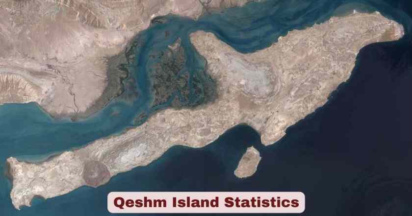
Tucked into the strategic waters of the Strait of Hormuz, Qeshm Island sits just off the southern coast of Iran in Hormozgan Province, separated from the Iranian mainland by the narrow Clarence Strait (Khuran). The island lies opposite the port cities of Bandar Abbas and Bandar Khamir, with its closest point just 2 kilometres from the mainland and its city centre approximately 22 kilometres from Bandar Abbas. Geographically, the island is bordered to the north by Bandar Abbas, to the northeast by Hormuz Island, to the east by Lark Island, to the south by Hengam Island, and to the southwest by the Greater and Lesser Tunbs and Abu-Musa Island. This arrow-shaped landmass — some say dolphin-shaped — lies at coordinates 26°50′N, 56°0′E, placing it squarely at one of the world’s most critical maritime chokepoints.
What makes Qeshm Island in 2026 truly extraordinary is not just its location but what that location represents. Over 20% of the world’s oil supply moves through the Strait of Hormuz daily, and Qeshm sits at the very entrance of that corridor. The island stretches 135 kilometres in length and spans 40 kilometres at its widest point, making it the largest island in the Persian Gulf and nearly 2.5 times the size of Bahrain. As a UNESCO Global Geopark, a designated Free Trade Zone, and one of Iran’s most visited tourist destinations, Qeshm is simultaneously a geological wonder, an economic hub, and a living cultural museum — all packed into 1,491 square kilometres of Persian Gulf coastline.
Interesting Facts About Qeshm Island 2026
Before diving into the raw statistics, here are some of the most compelling and lesser-known facts about Qeshm Island that set it apart from every other island in the Persian Gulf and the broader region.
| # | Fact | Detail |
|---|---|---|
| 1 | Largest island in the Persian Gulf | Total surface area of 1,491 km², nearly 2.5× the size of Bahrain |
| 2 | World’s longest salt cave | Namakdan Salt Cave stretches 6.58 km and is listed in the IUGS First 100 Geological Heritage Sites |
| 3 | Only UNESCO Geopark in the Middle East | Designated a UNESCO Global Geopark in 2017 |
| 4 | Free Trade Zone since 1991 | One of Iran’s first two free trade zones, established under the Free Zones Law of 1992 |
| 5 | 20-year income tax exemption | All businesses in the Qeshm Free Zone enjoy full tax exemption for 20 years |
| 6 | 1.6 million tourists in just 4 months | 1,660,251 tourists visited Qeshm in the first 4 months of the Iranian year 1403 (2024) |
| 7 | 25% of Iran’s native birds | The Hara Mangrove Forests host 25% of Iran’s native bird species annually |
| 8 | $257 million in exports (2024–25) | Qeshm Free Zone recorded $257 million in exports over 11 months (March 2024–Feb 2025) |
| 9 | $113 million trade surplus | Qeshm posted a trade surplus of $113 million in the same period |
| 10 | 59 towns and villages | The island is home to 59 distinct towns and villages |
| 11 | Visa-free entry by air | Foreign visitors arriving by plane and staying on the island can enter without an Iranian visa |
| 12 | 33% export growth in early 2025 | Qeshm Free Zone exports rose 33% in value in the first four months of the Iranian year 1404 (March–June 2025) |
| 13 | Hawksbill turtle sanctuary | Around 25 km of Shibderaz Village’s southern coast is a protected turtle breeding and hatchery area |
| 14 | Mangrove forest over 100,000 hectares | The Hara Mangrove Forest spans more than 100,000 hectares along the northern coast |
| 15 | Population ~180,000 (2026 estimate) | UNESCO Geopark data estimates roughly 180,000 residents, up from 148,993 in the 2016 census |
Source: Wikipedia, UNESCO Global Geopark Programme, Tehran Times, Qeshm Free Zone Organization (QFZO), Qeshm Geopark Organization
Qeshm Island is not your average destination, and these facts make that abundantly clear. The Namakdan Salt Cave, at 6.58 kilometres, holds a record that no other salt cave on earth can claim, and its listing among the International Union of Geological Sciences (IUGS) First 100 Geological Heritage Sites in October 2022 was a global recognition long overdue. Meanwhile, the island’s status as the only UNESCO Global Geopark in the entire Middle East — earned in 2017 — underlines how geologically and ecologically unique this Persian Gulf island truly is. The range of facts here tells the story of an island that punches far above its weight, from world-record caves and migratory bird sanctuaries to billion-dollar trade flows and visa-free tourism.
What’s equally striking is the economic momentum behind these facts as of 2026. A $113 million trade surplus, 33% export growth, and a Free Trade Zone offering 20-year tax holidays and 100% foreign ownership rights point to an island that is not just a tourist curiosity but a genuine business destination. The 1.66 million tourists arriving in just four months of 2024 — a 10% jump over the prior year — signal that Qeshm’s tourism engine is accelerating, even as it simultaneously grows its industrial and trade profile. These facts together paint the picture of an island at a pivotal moment in its development.
Qeshm Island Geography Statistics 2026
| Geographic Parameter | Data |
|---|---|
| Total Surface Area | 1,491 km² (576 sq miles) |
| Length | 135 km |
| Maximum Width | 40 km |
| Minimum Width | 9.4 km |
| Distance from Mainland (closest point) | 2 km |
| Distance from Bandar Abbas (city centre) | 22 km |
| Distance from Omani port of Khasab | 60 km |
| Distance from UAE’s Mina Rashid | ~180 km |
| Free Trade Zone Area | 300 km² |
| Province | Hormozgan, Iran |
| Governing Body | Qeshm County, Central District |
| Coordinates | 26°50′N, 56°0′E |
Source: Wikipedia, Qeshm Free Zone Organization (QFZO), Uppersia
Qeshm Island’s geography is the foundation of everything that makes the island exceptional. At 1,491 square kilometres, it is the largest island in the Persian Gulf and dwarfs its nearest neighbour, Bahrain, by a factor of 2.5. Its 135-kilometre length gives it a coastline that varies dramatically — from rocky shores and mud flats in the northwest to sandy beaches and coral reefs in the south. The island’s position at the Strait of Hormuz, just 60 kilometres from the Omani coast and 180 kilometres from the UAE’s Mina Rashid, places it at the strategic heart of global energy shipping, a fact that has shaped its history, economy, and military significance for centuries.
The 300 km² Free Trade Zone, which occupies roughly 20% of the island’s total area, is a deliberate carve-out designed to attract investment and facilitate international commerce without the regulatory constraints of mainland Iran. The geography also explains the island’s ecological richness — sitting at the border between the Persian Gulf and the Sea of Oman, Qeshm straddles two distinct marine ecosystems. This dual exposure drives the formation of vast coral reefs, mangrove belts, and sandy beaches within a remarkably compact area. The island’s proximity to the mainland — just 2 kilometres at its closest — also makes it uniquely accessible by ferry, a logistical advantage that directly supports its booming tourism numbers.
Qeshm Island Population Statistics 2026
| Census/Estimate Year | Population | Households |
|---|---|---|
| 2006 Census | 103,881 | 22,642 |
| 2011 Census | 117,774 | 28,798 |
| 2016 Census | 148,993 | 40,506 |
| 2016 Census – Qeshm City only | 40,678 | 11,945 |
| 2026 Estimate (UNESCO Geopark data) | ~180,000 | N/A |
| Additional workforce (non-resident) | ~30,000 | N/A |
| Total effective daytime population (2026) | ~210,000+ | N/A |
| Number of Towns and Villages | 59 | — |
| Number of Cities in the county | 4 | — |
Source: Wikipedia (Qeshm County), Statistical Centre of Iran, UNESCO Global Geopark Programme, Qeshm Island Environmental Management Office (UN SDG Partnership)
The population of Qeshm Island has grown steadily across every available census, rising from 103,881 in 2006 to 148,993 in 2016 — a 43% increase over a single decade. The most recent estimate available as of 2026 — drawn from UNESCO Geopark data — puts the resident population at approximately 180,000, which would represent yet another significant jump since the last official count. The 2016 census for Qeshm City alone recorded 40,678 residents in 11,945 households, confirming that while the island is composed of 59 towns and villages, a substantial share of the urban population clusters in the administrative capital. An additional estimated 30,000 non-resident workers — comprising administrative staff, industrial workers, and students — bring the island’s effective daytime population considerably higher.
This demographic growth is not accidental. The Qeshm Free Trade Zone, established in 1991, has been a major pull factor for economic migration, bringing workers and entrepreneurs from across Iran and beyond. The island’s expanding trade, tourism, and industrial sectors continue to attract new residents, putting pressure on housing, water infrastructure, and public services. The fact that the island’s water desalination plant serves 30 villages — a figure highlighted in recent international reporting — underscores just how critical infrastructure development is to sustaining this population growth trajectory through 2026 and beyond.
Qeshm Island Climate Statistics 2026
| Climate Parameter | Data |
|---|---|
| Climate Type | Hot and arid (semi-tropical/subtropical) |
| Average Annual Temperature | ~27°C (81°F) |
| Average Maximum Temperature (recorded) | 46°C |
| Average Minimum Temperature (recorded) | 18°C |
| Average Annual Rainfall | 183.2 mm (Geopark source: ~120 mm) |
| Warmest Months | June – August (often exceeds 40°C) |
| Coldest Months | October – January |
| Best Time to Visit | November – March |
| Winter Temperature Range | 15°C – 25°C |
| Spring/Autumn Temperature Range | 20°C – 30°C |
Source: Wikipedia, Qeshm Geopark Organization, IranAmaze Travel Guide 2025, Iran Safar
Qeshm Island’s climate is one of the most defining characteristics of life on the island, and it directly shapes the rhythm of tourism, agriculture, and daily activity. The island sits in a hot, arid, semi-tropical zone, with summer temperatures routinely crossing 40°C and the recorded maximum sitting at a punishing 46°C. This extreme summer heat — combined with high humidity from the surrounding Persian Gulf — makes the months of June through August largely inhospitable for outdoor tourism, pushing visitor seasons firmly into the cooler winter and spring windows. The average annual temperature of 27°C masks this seasonal extremity, giving a deceptively moderate impression of what is actually a climate of sharp contrasts between scorching summers and pleasant, mild winters.
The winter months of November through March have become the peak tourist season for exactly this reason, with temperatures sitting comfortably between 15°C and 25°C — ideal for exploring the island’s canyons, mangrove forests, and beaches. The island’s annual rainfall of approximately 120–183 mm is low enough to classify the environment as arid, which explains both the dramatic desert landscapes (like the Valley of Stars and Chahkooh Canyon) and the chronic freshwater scarcity that has historically made water management a central concern for the island’s communities. Traditional water wells carved into the walls of Chahkooh Canyon by early inhabitants stand today as silent testimony to how seriously generations of Qeshmi residents have taken the challenge of surviving in this climate.
Qeshm Island Free Trade Zone (FTZ) Statistics 2026
| FTZ Parameter | Data |
|---|---|
| Year Established | 1991 (legally founded under the 1992 Free Zones Law) |
| FTZ Area | ~300 km² |
| Income Tax Exemption Period | 20 years (all economic activities) |
| Foreign Ownership Allowed | 100% (no local partner required) |
| Customs Duty on Raw Materials/Machinery | Exempt |
| Capital/Profit Repatriation | 100% freely permitted |
| Qeshm FTZ Exports (Mar 2024 – Feb 2025) | $257 million |
| Qeshm FTZ Imports (same period) | $143 million |
| Qeshm FTZ Trade Surplus (same period) | $113 million |
| Export Growth (Mar–Jun 2025) | +33% year-on-year |
| Target Investment per Zone by 2028 | $10 billion (government target) |
| Port Capacity (bulk cargo across all Iranian FTZs) | 61 million tons |
Source: Tehran Times (Feb 28, 2025), Qeshm Free Zone Organization, Economic Ideal (Nov 2025), British Iranian Chamber of Commerce (BICC)
The Qeshm Free Trade Zone is one of the most significant economic structures on the island and, by extension, one of the most important in the entire Persian Gulf. Established in 1991 as one of Iran’s first two free trade zones — alongside Kish Island — it operates across 300 square kilometres of the island’s western portion and offers an investment environment that is deliberately designed to be as attractive as possible to both domestic and foreign capital. The flagship incentive is the 20-year income tax exemption covering all commercial, industrial, and service activities, combined with 100% foreign ownership rights and unrestricted capital repatriation. These terms are highly competitive by regional standards and explain why the zone has steadily attracted investors despite Iran’s broader sanctions environment.
The trade data for March 2024 through February 2025 makes a compelling case for Qeshm’s growing commercial clout. Exports of $257 million against imports of $143 million produced a healthy trade surplus of $113 million, making Qeshm the top-performing free zone by trade surplus among all of Iran’s free trade areas in that period — ahead of Kish ($104 million surplus) and Aras ($28 million surplus). The 33% export growth recorded in the first four months of the Iranian year 1404 (March–June 2025) signals that this upward momentum is continuing into 2026. With the Iranian government targeting a minimum of $10 billion in investment per free zone by 2028, Qeshm’s infrastructure — including the upgraded Shahid Zakeri Wharf and Qeshm International Airport — is being positioned to handle a much larger volume of trade in the years ahead.
Qeshm Island Tourism Statistics 2026
| Tourism Metric | Data |
|---|---|
| Tourists in first 4 months of Persian year 1403 (2024) | 1,660,251 |
| Tourists in same period of Persian year 1402 (2023) | 1,499,065 |
| Year-on-year increase | +161,186 tourists (+10%) |
| Entry Routes | Sea, Air, and Land |
| Visa Requirement (air entry, island-only stay) | Free visa / Visa-exempt |
| Best Tourist Season | November – March |
| Peak activity months | Autumn, Winter, Spring holidays |
| Passenger capacity (all Iranian FTZ ports combined) | 12 million annually |
| Top Attractions | Namakdan Salt Cave, Valley of Stars, Hara Forest, Chahkooh Canyon, Hengam Island dolphins |
| Ferry frequency from Bandar Abbas | Every 30 minutes (7 am – 11 pm) |
| Ferry travel time from Bandar Abbas | ~45 minutes |
Source: Tehran Times (Aug 14, 2024), IranAmaze 2025 Travel Guide, OrientTrips (Jan 2026), Qeshm Free Zone Organization
Qeshm Island’s tourism sector is on a clear and convincing upward trajectory, backed by official figures that leave little room for doubt. The 1,660,251 tourists who arrived in just the first four months of the Iranian year 1403 (starting March 2024) represent more than 1.1 million people per month — a striking pace for an island of this size. The 10% year-on-year growth over the same period in 2023 is especially significant because it comes on top of an already elevated base, confirming that Qeshm is not experiencing a one-off spike but a sustained increase in visitor interest. Tourists arrive via three main routes — sea, air, and land — with the sea route from Bandar Abbas being the most popular, operating every 30 minutes throughout the day with a travel time of approximately 45 minutes.
The island’s visa-free policy for air arrivals who stay only on Qeshm is a major competitive advantage in a country that otherwise requires advance visa arrangements for most nationalities. This policy has opened the island to spontaneous international visits, particularly from travellers in the UAE, Oman, and Gulf states, who can reach Qeshm in a short flight without the bureaucratic hurdle of a full Iranian visa. The tourism calendar is firmly anchored in the cooler months, with autumn, winter, and spring being peak seasons when the island’s outdoor attractions — the Valley of Stars, Chahkooh Canyon, dolphin-watching tours off Hengam Island, and mangrove kayaking in the Hara Forest — can be properly enjoyed. This seasonal concentration also means that Qeshm’s tourism infrastructure, while growing rapidly, continues to face capacity pressure during peak holiday periods.
Qeshm Island Geological & Environmental Statistics 2026
| Environmental Parameter | Data |
|---|---|
| UNESCO Global Geopark designation year | 2017 |
| Geopark status | Only UNESCO Geopark in the Middle East |
| Namakdan Salt Cave length | 6.58 km (world’s longest salt cave) |
| Salt dome height (Namakdan) | 237 metres above sea level |
| Hara Mangrove Forest area | More than 100,000 hectares |
| Mangrove species | Avicennia marina (grey mangrove) |
| World bird species hosted annually | ~1.5% of all world bird species |
| Iran’s native bird species hosted | ~25% of Iran’s native birds |
| Hawksbill turtle sanctuary (Shibderaz) | ~25 km of protected coastline |
| Valley of Stars geological age | ~2 million years (Cenozoic period) |
| Zagros Mountain range length | 1,800 km (island sits at its southern edge) |
| IUGS heritage listing | Included in First 100 IUGS Geological Heritage Sites (October 2022) |
Source: UNESCO Global Geopark Programme (Qeshm), Wikipedia, Qeshm Geopark Organization, Community Conservation Research Network
Qeshm Island’s geological and environmental credentials are among the most impressive of any island in the Persian Gulf or the broader Middle East region. The island’s designation as a UNESCO Global Geopark in 2017 — the only one in the entire Middle East — was a recognition of the extraordinary variety of geological formations packed into its 1,491 square kilometres. At the island’s core is the Namakdan Salt Cave, stretching 6.58 kilometres underground, making it the longest salt cave in the world. Formed within a massive salt diapir that dates back to the late Proterozoic era, the cave features multicoloured galleries, salt crystals, and an air quality so pure it is used therapeutically for patients with respiratory conditions. Its listing among the IUGS First 100 Geological Heritage Sites in October 2022 reinforced its global scientific significance.
Beyond the cave, the island’s ecological statistics are equally remarkable. The Hara Mangrove Forest, covering more than 100,000 hectares along the northern coast, is one of the most important wetland ecosystems in the Middle East. It hosts approximately 1.5% of all world bird species and 25% of Iran’s native birds annually — a biodiversity statistic that attracts ornithologists and ecotourists from across the globe. The 25-kilometre Hawksbill turtle sanctuary at Shibderaz Village represents a rare success story of community-led conservation, where local residents who once harvested turtle eggs have become dedicated protectors of a globally endangered species. These environmental facts are not static heritage items — they are living systems under active management, and they form the ecological backbone of the island’s rapidly growing ecotourism economy in 2026.
Qeshm Island Energy & Industrial Statistics 2026
| Energy/Industry Parameter | Data |
|---|---|
| Gavarzin Gas Field annual output | 2 million m³ of sweet gas (supplies Bandar Abbas power plant) |
| Salakh Gas-Condensate Field | Untapped; reserves believed to exceed Gavarzin |
| First heavy crude oil refinery (launched) | June 2022 – capacity 70,000 bpd |
| Direct jobs created in FTZ by 2021 | ~40,000 direct jobs |
| Indirect jobs created | ~2,000–3,000 |
| Number of higher education institutions | 10+ on the island |
| Refinery investment (pipeline to Bandar Abbas refinery) | $140 million |
| Port type | Panamax-class capable |
| North-South transit corridor role | Key node connecting Indian Ocean to Central Asia via Iran |
Source: Offshore Technology, Grokipedia (citing Iranian official statements), Qeshm Free Zone Organization, investinhormozgan.ir
Qeshm Island’s energy and industrial landscape represents a layer of economic activity that runs parallel to — and often intersects with — its trade and tourism sectors. The island sits atop significant hydrocarbon resources. The Gavarzin gas field produces 2 million cubic metres of sweet gas annually, supplying the power plant in Bandar Abbas, while the Salakh gas-condensate field — still largely untapped as of 2026 — is believed to hold reserves that rival or exceed Gavarzin’s output. The landmark moment for Qeshm’s industrial profile came in June 2022, when the first phase of a 70,000-barrel-per-day extra-heavy crude oil refinery came online — marking Iran’s first-ever facility for processing extra-heavy crude feedstock and positioning Qeshm as a downstream energy hub in its own right.
The Free Trade Zone has driven significant employment growth alongside this industrial activity. By 2021, approximately 40,000 direct jobs had been created within the zone, supported by more than 10 institutions of higher education and vocational training schools that ensure a pipeline of skilled local workers. The Panamax-class port facilities — capable of handling the largest class of cargo vessels that can transit the Panama Canal — complement the zone’s industrial capacity and directly support its role in the North-South Transit Corridor, which links the Indian Ocean through Iran to Central Asia and beyond. These industrial and energy statistics collectively paint a picture of an island that is building a diversified economy capable of sustaining far more than just tourism or trade alone.
Qeshm Island Key Distances & Accessibility Statistics 2026
| Route/Connection | Distance/Time |
|---|---|
| Qeshm Island to mainland (closest point) | 2 km |
| Qeshm City to Bandar Abbas | 22 km |
| Ferry from Bandar Abbas to Qeshm | ~45 minutes (every 30 min, 7 am–11 pm) |
| Car ferry from Bandar-e Pol to Laft Port | 20–30 minutes |
| Qeshm to Oman (port of Khasab) | 60 km |
| Qeshm to UAE (Mina Rashid) | ~180 km |
| Qeshm International Airport (IATA: GSM) | ~20 km northeast of city centre |
| Domestic flights available from | Tehran, Mashhad, Shiraz, and other major Iranian cities |
| International flights available from | Dubai (occasional) |
| Ferry from Hormuz Island to Qeshm | Available daily (morning, return afternoon) |
| Distance from Tehran | ~1,353 km |
Source: Wikipedia, Against the Compass travel blog (Nov 2025), Iran Safar, PersianWalk 2024, Qeshm Free Zone Organization
Qeshm Island’s accessibility has improved considerably over the years and remains one of the key drivers behind its tourism growth. The combination of ferry services running every 30 minutes between Bandar Abbas and Qeshm — from 7 am to 11 pm daily — means that casual visitors can arrive, spend the day, and return without any advance planning. For those travelling by car, the 20–30 minute car ferry from Bandar-e Pol to Laft Port on the island’s northern coast provides a seamless road connection to the mainland. Qeshm International Airport (IATA: GSM), located approximately 20 kilometres northeast of the city centre, handles domestic flights from Tehran, Mashhad, Shiraz, and other major Iranian cities, as well as occasional international connections from Dubai — the latter being particularly important for Gulf-region visitors who wish to use the island’s visa-free entry policy.
The island’s regional proximity to both Oman (60 km) and the UAE (~180 km) has long given it a natural role as a gateway between Iran and the Gulf Cooperation Council (GCC) states, and this positioning continues to inform the Free Trade Zone’s commercial strategy in 2026. With plans to build a bridge connecting Qeshm to mainland Iran still on the long-term infrastructure agenda, the island’s current ferry-based connectivity remains both a charm and a constraint. The distance from Tehran of approximately 1,353 kilometres means that for Iranian domestic tourists, flying remains the most practical option, and the expansion of flight frequencies from major Iranian cities has been a direct enabler of the island’s surging visitor numbers in recent years.
Disclaimer: This research report is compiled from publicly available sources. While reasonable efforts have been made to ensure accuracy, no representation or warranty, express or implied, is given as to the completeness or reliability of the information. We accept no liability for any errors, omissions, losses, or damages of any kind arising from the use of this report.